Introduction to ISRO’s NavIC
NavIC is an Indian regional navigation satellite system and it can do navigation with the Indian constellation. This navigation system is capable of providing real-time positioning and timing this is the major service provided by the NavIC. This is a regional satellite system that is capable of providing accurate details regarding the positioning, timing, and navigation service based on India and also the regions close to it. The chip does the navigation based on the Indian constellation.
What is the full form of NavIC and what are the major features of NavIC?
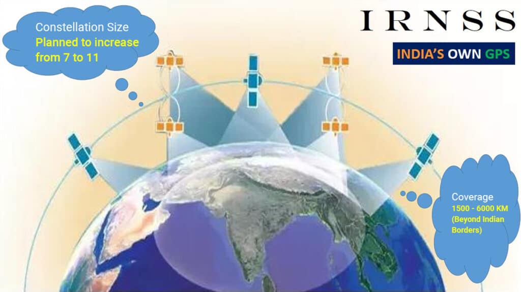
NavIC stands for navigation with the Indian constellation. This navigation system is composed of seven satellites and these satellites will be in geosynchronous orbit. NavIC will be able to cover up to 1500 km around India. This navigation system will provide us with our own global positioning system and thus we don’t need to depend on other global positioning systems. The ground stations of this navigation system will operate 24/7. This navigation system works in L5 band signals and this frequency range is specifically for the Indian system. This specified frequency range will provide better operations with less interference.

NavIC was formerly known as the IRNSS. This navigation system can be used for real-time information which can be used for military operations. This global positioning system will be handy for technological and scientific advancement in India.
How NavIC is different from GPS and GLONASS? Is NavIC better than GPS?
GPS and GLONASS both of these navigational systems are under the defense sector. So the civilian service provided by the GPS and the GLONASS will be less when compared to the NavIC. NavIC is a regional navigation system the area covered by the NavIC will be different from the GPS and GLONASS. The satellite which is used for GPS navigation will circle the earth more than once a day, mostly it will circle two times.
The GPS system will operate in the L1 band and this will also be shared with another navigational system. But the NavIC uses L5 and S frequency bands which is only for India. The GPS and GLONASS have global coverage. The accuracy of the NavIC is similar to the GPS, because of this we don’t need to depend on the foreign navigation system. GPS will get you to reach 20 meters of your target while the NavIC can help you to reach 5 meters of the target. This feature of NavIC is really useful for military operations. So in particular cases, NavIC is better than the GPS, in the future we can expect several updates in this navigation system.
Is the NavIC for military purposes or is it available for public use?
NavIC will provide its service for civilians and also it will be used for national security.
What are the seven satellites which are used in the NavIC navigation system?
- IRNSS-1A
- IRNSS-1B
- IRNSS-1C
- IRNSS-1D
- IRNSS-1E
- IRNSS-1F
- IRNSS-1G
Three of these satellites are in the geostationary orbit, and the rest are in the inclined geosynchronous orbit.
The primary services provided by this navigational system
- It provides standard position service for civilian users
- Strategic services will be provided for the restricted users
Can ISRO’s NavIC become a global positioning tool?
NavIC is capable of providing positioning and timing services. The service region of the NavIC is mostly for India and its border region. This navigation system can also be useful for national security and it has 7 satellites for the navigation purpose. In the future, there could be more satellites so that this regional navigation system could achieve global coverage. The space section of the NavIC will be supported by the necessary ground infrastructure. This navigation system is mostly required for the civil aviation sector. It has several applications in different sectors from military to scientific operations.
What are the major challenges faced by NavIC?
The coverage area of the NavIC is really less when compared to other navigation systems. The Constellation of this satellite system is really less. User acceptance is less and also the growth strategy in the market is really low. Due to all these reasons, NavIC is not used for a global positioning system. The service for civilians which is offered by the NavIC is not supported by most smartphones because of the frequency band constraints.
How does the ISRO’s NavIC work?
NavIC operation is carried out with 7 satellites all these satellites are in the line of sight with India. These satellites will rotate at a specified velocity to keep the line of sight with India properly. Three of the satellites in the NavIC are in the geostationary orbit. These three satellites are constantly in the line of sight with the ground station. NavIC satellites have Rubidium Atomic clocks that can calculate the time, distance, and position. All these calculations will be carried out with the help of radio frequencies.
NavIC uses two frequencies and because of this, the accuracy is really great. This navigation system is composed of eight satellites and 7 of them are active. The major objective of NavIC is to provide navigational, timing, and positioning services all over India. The service of this navigation system will be carried out by S-band and L5 band.

NavIC will utilize the L1 band in the future to provide better service. India didn’t receive any authorization to use the L1 and L2 frequency bands. Most smartphones don’t support the S and L5 bands. The L1 and L2 frequency bands are used worldwide for telecommunication purposes. In the future, NavIC will use L1 and L2 bands, so this problem can be solved.
What is the coverage area of the NavIC?
NavIC is capable of covering the whole of India and also it will cover some parts of our neighboring countries. NavIC will also cover Indian borders so this satellite can also cover our bordering countries such as Bangladesh, Pakistan, Sri Lanka, and some portions of China.
What are the major advantages of the NavIC?
This navigation system will provide precise navigation and timing. We don’t need to rely on another navigation system. It can be used for several purposes such as agriculture, military, etc. The frequency band of the NavIC is specifically for this regional navigation purpose so there will be very little interference. The signals from the NavIC reach India at a 90-degree angle and due to this there will be good service in the remote areas.
What are the major applications of NavIC?
- Marine navigation
- It can be used for disaster management
- Tracking vehicles
- Voice navigation in vehicles
- Navigation aid for tourists
- Monitoring resources
- Geodesy and surveying
- Smartphone integration
- It can be used for national security
- Mapping
- Visual imaging for navigation
- Positioning service
Author – ASHLIN A J

